Nepal is highly vulnerable to riverine disasters like floods, debris flows, and glacial lake outburst floods (GLOFs) because of complex hydrological, geological, and climatic processes. In 2024, 249 lives were lost, 10,800 households were displaced, and assets worth 38.9–46.7 billion Nepalese rupees were destroyed. Similarly, 93 lives were lost, 4,100 households were affected, and huge economic loss resulted from the flood that occurred in 2025. Loss of lives, infrastructure, and economic disruption every year can be reduced by adoption of an integrated disaster management strategy.
Debris flows are particularly devastating, flowing at 30–50 km/h with water, soil, rocks, and vegetation that have the ability to erode boulders, trees, and buildings. Debris flows typically occur on steep slopes greater than 30°, with unstable material and high-intensity rainfall or rapid meltwater. GLOFs occur when glacier- or ice-dammed lakes suddenly burst explosively, releasing tremendous amounts of water and sediment, and landslide-dammed lakes also burst explosively, triggering erosive floods.
Monsoon rains reduce the stability of the soil, and increasing temperatures are accelerating glacial melting, facilitating increased development of glacial lakes and the potential for glacial dam failure. Steep catchment streams have high debris cover, occasionally in the form of ephemeral dams that have the potential to collapse abruptly.
Human activities such as road construction, slope and river cutting, mining, and spontaneous settlements destabilize slopes and hamper drainage, increasing hazards. Inadequate surveillance and early warning due to the limitations of hydrometeorological networks increase the impact of disasters.
Risk of erosion, landslide and debris flow in rivers and stream...

Climate Change Multiplying the Disaster Risk
Climate change is exacerbating riverine risk. High-altitude temperatures are rising by 0.03–0.06°C annually, facilitating fast glacier melting and glacial lake expansion. Unseasonal rains and short, intense events now trigger peak runoff in minutes, overflowing rivers and triggering landslides that combine with floodwater. For the next three decades until 2050, long sequences of dry spells interspersed with episodic surges of heavy rainfall are likely, enhancing flash flood and GLOF risk. Fragile landslide dams and glacial deposits will be most prone to such conditions. Deforestation, human activities, unplanned settlements, and poor infrastructure design reduce the stability of slopes and increase susceptibility.
Recent Devastating Disasters
Melamchi Flood occurred in 2021 because of excessive rainfall, which overtopped a landslide dam and inundated Melamchi Bazaar with debris flows and destroyed agricultural land, houses, and infrastructure. Inadequate slope monitoring and early warning were the primary reasons for the failure.
The Bagmati Flood in 2024, caused by heavy rain, brought widespread flooding in Kathmandu Valley, which resulted in over 200 deaths and displaced thousands of people. The flood revealed the urban encroachment of floodplains and the need for zoning and drainage improvement.
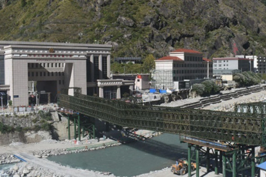
A glacial lake outburst flood and rain surge destroyed the Nepal-China Friendship Bridge, 11 people died, and 17 people were missing in Rasuwagadhi Flood in 2025. The disaster revealed lapses in cross-border coordination for disaster management.
In Uttarkashi district of India, one person was killed and 68 people were missing from a debris flow due to a cloudburst during Dharali Flash Flood in 2025, showing the danger of settlements in risky areas. These disasters show the need for continuous observation of glacial and landslide-dammed lakes, downstream settlement hazard exposure mapping, real-time early warning systems, and climate-resilient infrastructure and urban planning.
Key Riverine Disaster Management Strategies
Nepal is very susceptible to riverine risks due to steep terrain, poor geology, heavy monsoon rains, and expanding glacial systems. Limited monitoring capacity, institutional vulnerabilities, and uncontrolled development add to the threats. Some of the strategies to be adopted for effective disaster management are discussed below.
- Establishment of Early Warning and Monitoring
Nepal's scarce hydrological stations, minimal maintenance, and reliance on informal communication equate to poor forecasting capacity and insufficient lead times. Intensive surveillance networks of automatic gauges, Doppler radar, and real-time data handling linked with multi-platform warnings are effective in Japan. Nepal should focus on increasing automatic river gauges, satellite rainfall observations, and centralized forecast models. Community-based sirens and SMS warnings, proper calibration and validation of models, and conducting training and capacity development programs would improve preparedness. - Building Resilient Infrastructure
The roads, bridges, hydropower structures, and embankments of Nepal are planned with an emphasis on historical hydrology without considering multiple hazards like debris load, seismic impact, and climate change impacts. The facilities also do not function properly during disasters due to the use of low serviceability materials and inappropriate maintenance failures. Developed countries mostly conduct rigorous hydraulic, sediment, and seismic analysis during design, use robust construction materials, and perform periodic inspections. Nepal must revise design codes for the integration of climate and sediment modeling, utilization of resilient materials, and enforcement of national inspection plans. - Adopt Proper Land-Use Planning and Settlements
Haphazard slope cultivation, floodplain encroachment, and uncontrolled riverbed extraction increase Nepal's exposure to disasters. In Japan, these are strictly regulated through zoning, the creation of hazard maps for all municipalities, and construction regulation in disaster-sensitive areas. Nepal must make floodplain zoning operational through GIS-based maps, relocate from disaster-prone areas, regulate riverbed extraction, and publish basic hazard maps for use by communities and planners. - Effective Transboundary Coordination
Nepal's forecasting suffers from data sharing by China, particularly for upstream rainfalls, GLOFs, and dam releases. Nepal must institutionalize upstream data sharing through bilateral agreements and basin commissions, and an integrated approach towards basin-wide river management. - Enhance Community Preparedness
Most Nepali households lack evacuation plans, drills, and emergency materials, and are ineffective for warnings. Annual drills, dispensation of hazard maps, and flood risk education at schools in Japan make preparedness a way of life. Nepalese cities have to be compelled to conduct regular drills, chart out evacuation routes, and conduct risk education at schools. - Execute Integrated Risk Assessment Approach
Fragmented planning, frequently considering cascading and compounding disasters such as rainstorm-induced landslides triggering debris flow, defies the disaster management effort. Japan employs calibrated models through physical experiments coupled with basin models to address multi-hazard risk. It is necessary for Nepal to establish institutes of research to develop coupled hazard models, require basin-level risk assessment in infrastructure planning, and collaborate with foreign institutions to deliver high-level service. - Climate-Adapted Strategies
Infrastructure design has been carried out based on historical hydrology, without consideration for climate change impact in extremes. Japan incorporates future climate change projections into design codes, reservoir management, and basin planning. Nepal shall upgrade design standards based on regional projections, adopt flexible flood storage, include reforestation, and create long-term master plans for adaptive land use. Conclusion
Nepal's river disasters are worsened by institutional deficiencies, technical weaknesses, unplanned development, and climate change. The value of integrating structural resilience, monitoring and warning capacity, land-use planning, cross-border coordination, and community readiness is vital for disaster management, learning from countries like Japan. By implementing climate-resilient infrastructure, GIS-based zoning, real-time forecasting and warning, and considering climate change impact in design, Nepal can reduce the impacts of floods and debris flows, enhance resilience, and foster sustainable development in its disaster-affected mountains.
Er. Dr. Suresh Laudari, PhD in Civil Engineering (Hydro-Geo-hazards) from Ehime University, Japan, is a researcher on water disasters at Kochi University, Japan.
Er. Sanjeeb Baral, PhD Scholar in Civil Engineering (Water Resources Planning and Management) at IoE, T.U., is the Executive Director of the Water Resources and Energy Research Centre and former Director General of the Department of Water Resources and Irrigation.