Saturday, 27 April 2024 04:54 AM
OR
Login using
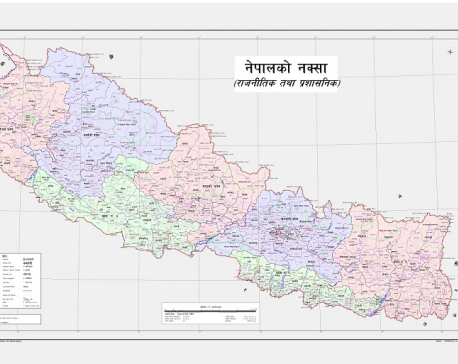
Nepal’s new map covers an area of 147,516 sq km, 10,000 copies being printed
May 21, 2020 12:29 pm
KATHMANDU, May 21: Nepal released its revised political and administrative map which incorporates Limpiyadhura, Lipu Lekh and Kalapani, the territories encroached upon by India. Amidst a televised press conference at the Ministry of Land Reforms and Management at Singha Durbar on Wednesday, Minister Padma Aryal unveiled the new political and administrative map of Nepal.
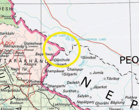
India unilaterally constructs link road to Tibet through Nepali territory of Lipulekh
May 9, 2020 09:03 am
KATHMANDU, May 9: India on Friday inaugurated a strategic link road connecting Dharchula of the Indian State of Uttarakhand and the Tibetan Autonomous Region (TAR) of China via the Lipulekh Pass, a Nepali territory which lies in the country's north western frontier with China.
Trending


Just In
- CM Kandel requests Finance Minister Pun to put Karnali province in priority in upcoming budget
- Australia reduces TR visa age limit and duration as it implements stricter regulations for foreign students
- Govt aims to surpass Rs 10 trillion GDP mark in next five years
- Govt appoints 77 Liaison Officers for mountain climbing management for spring season
- EC decides to permit public vehicles to operate freely on day of by-election
- Fugitive arrested after 26 years
- Indian Potash Ltd secures contract to bring 30,000 tons of urea within 107 days
- CAN adds four players to squad for T20 series against West Indies 'A'