Saturday, 27 April 2024 10:58 AM
OR
Login using
Saving Salahesh Fulbari and the Eastern Churia Landscape
Published On: May 19, 2020 01:15 PM NPT By: Dr Kanchan Thapa

Dr Kanchan Thapa
Thapa is a Conservation Biologist and the Wildlife Lead at WWF Nepalnews@myrepublica.com
More from Author
"Biologists often begin autobiographical sketches by describing an idyllic childhood spent in a company of bugs and salamander," says Eric Dinerstein, a noted wildlife biologist. For me, it was no different. I sketched my childhood, a boy from Kathmandu,] who spent two months of winter vacations in the warm and dusty plains of Salahesh fulbari, playing with the buffalo shepherd, fishing and taking mud baths in the paddy fields. Geographically located in Lahan Municipality in Siraha district, Salahesh fulbari includes six hectares of forested gardens with historical and cultural significance. The area was famous for a species of orchid that was believed to bloom only on the eve and first day of the Nepali new year. Underground water ran through this garden, forming small rivulets, flowing out, and used by hundreds of villagers to water their paddy fields. These deeply rooted cultural beliefs—tied to the various ecosystem services that the land provides to locals—explains fulbari’s significance.
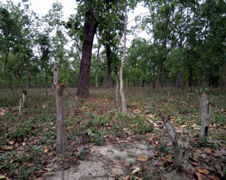
I have no memory of any other natural forest around my village. As a child, every dawn I would watch the hundreds of villagers march to the northern side of the village along the churia range—armed with a Bancharo (axe), a small polta (pouch) and chewraa & gund (beaten rice and raw sugar) for lunch. At dusk, they would return, bringing back loads of daura (fuelwood) and baans (bamboo). The Churia landscape, located about 10-15 km from my village, has been the primary source of fuelwood for millions of people living around it.
I personally love to refer to the Churia as Manchurian or the heart-warming Churia. The Churia range that runs east to west along the country, sandwiched between the plains and mid-hills of Terai, forms one of five physiographic zones (Terai, Churia, Mid hills, High Mountains and the Himalayas) within the country. While considered a physically fragile habitat, it provides important ecological services by recharging water tables underneath, extending cover for forest-dwelling wildlife and maintaining soil cover, helping vast lush green agricultural fields prosper in the plains. Realizing the importance of the Churia range, it was identified as a top conservation priority by the Government of Nepal in 2010 under the President Chure Conservation Programme for integrated management of land, water, forests and ecological balance.
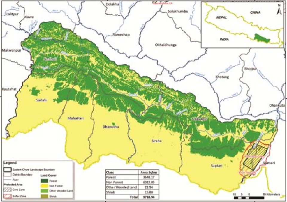
While the Government of Nepal has prioritized important landscapes for conservation, only a part of the Churia range was included as part of the Terai Arc Landscape-Nepal; which runs westward from Bagmati river to Mahakali River. As such, a part of the Churia range in the eastward direction does not fall under any of the priority landscapes and could be better managed under a landscape approach. The Eastern Churia Landscape (ECL) measures ~ 9,700 square kilometers and encompasses nine districts with more than half a million of Nepal’s population residing there.
A preliminary survey of this landscape by WWF Nepal intending to visualize and map out forest connectivity between Bagmati River in the east and Koshi Tappu Wildlife Reserve in the west and determine the conservation significance of the Eastern Churia Landscape found important valleys within it, such as Marin, Kamala, Tawa, and Udayapur (also known as Bhitri Madhesh) that provided forested habitat and cover for wildlife dispersal within the landscape. Meanwhile the habitat in the landscape is also the last frontier for the large-ranging elephant, gaur, arna, leopard and many other small carnivores, as well as a historically remnant habitat for tigers. Elephant, long-ranging pachyderms, have also been reported at several places within the landscape along with conflict cases reported at the division forest offices. In the 70s, James L. Dave Smith, noted tiger biologist, reported a sighting of a tiger in the Trijuga forest, located in the western part of ECL. Locals have also reported tiger sightings along the Marin valley forest, but these accounts could not be verified. Ratuwa, nilgai, gaur, goral, bears have also been frequently seen traversing the landscape.
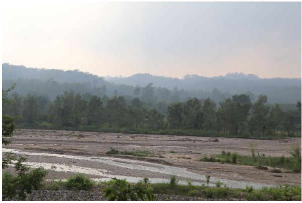
However, there are various issues in regard to the Eastern Churia Landscape with respect to forest cover, forest dwelling wildlife and ecosystem services. Grazing pressure, illegal logging, fuelwood extraction, encroachment, sand mining and continued cases of hunting are a few direct threats that loom over the ecological integrity of the landscape. These threats are compounded by ongoing construction of roads leading towards the new east-west highway, which run parallel to existing roads that join Hetauda and Chatara and pass through the valleys within ECL.
While these moves are indeed a step forward in achieving Nepal’s developmental ambitions, they also raise challenges and trigger further forest encroachment. Plans are also in place to expand the existing road that runs north to south through the ECL, which will only exacerbate the fragmentation of the landscape and promote rapid urbanization. This landscape forms a crucial part of the elephant dispersal range and as elephants return in search of their historical path—only to find that their route has been drastically altered or no longer exists—more cases of human wildlife conflict are expected to follow.
It’s not too late to conserve the landscape from further degradation. There are places to begin these efforts; large blocks of forests are still intact and uninterrupted. And there are approaches that have led to gains elsewhere. Nepal’s internationally recognized community-driven approach to natural resource management has led to successful restoration efforts throughout the country. Not to mention Nepal’s community forest programs and community-based organizations have gained worldwide recognition. Successful community-based conservation under the landscape approach can maintain the ecological integrity of the landscape in the long run. Two decades of experience in Terai Arc Landscape can be scaled out to the ECL, placing a much-needed check on urbanization with proper enforcement of land use policies, developmental mitigation measures in place and ultimately ceasing any further fragmentation.
Back in fulbari, I would not be surprised if cases of elephant conflict rise in the nearby villages, if forest connectivity in the landscape is broken in the long run. As of now, the people in my village are happy and content to irrigate their paddy fields with water from the forests of fulbari. But this feature hinges heavily on the survival of Churia, where underground water is recharged and runs into an underground table.
The existence of Terai and inner Terai—as well as all the people and wildlife that roam its paths or call the area home—are dependent on the conservation effort in this critical landscape. Let’s join efforts to save this unsung and often overlooked natural boon: The Eastern Churia Landscape.
Thapa is a Conservation Biologist and the Wildlife Lead at WWF Nepal
You May Like This

Deforestation rampant in Kailali
DHANGADI, Feb 3: Some 30 trees of 'Saal' species were found cut down in a national forest near Sanupal area... Read More...
Forest conservation public awareness week concludes
BIRATNAGAR, March 28: Stakeholders have insisted on the need for the concerned agencies to pay special attention on averting forest fire. Read More...
Govt initiates community-based project to conserve forests in eastern Nepal
KATHMANDU, Jan 31: Known as the Rhododendron capital of the Himalayas, Tinjure-Milkhe-Jaljale (TMJ) forest complex in eastern Nepal has long... Read More...


Govt yet to pay Rs 60 billion to contractors
28 minutes ago


NATO Serving as a Catalyst to Fuel Violence
2 hours ago
Just In
- Govt yet to pay Rs 60 billion to contractors
- Nepal’s poorest district identified as Bajura, richest as Mustang
- Wind storm likely at a few places of Koshi and Sudurpaschim
- EVs adoption in Nepal surge in Nepal with government support measures
- Mayors' Forum urges Finance Minister Pun to settle electricity dues
- By-Election: Voting underway in Ilam-2 and Bajhang-1(a)
- Save the Children report highlights severe impact of air pollution on children
- NATO Serving as a Catalyst to Fuel Violence
Leave A Comment