
OR
Over excavation in Chure triggers inundation in Madhes
Published On: May 29, 2019 04:00 AM NPT By: Mithilesh Yadav
LAHAN, May 29: Until two decades ago, the muddy water released from the Chure hills increased the fertility of the land and added to the productivity in Tarai. However, the same water has started bringing sand and pebbles with it these days. This is not just ruining the arable land but also decreasing its productivity.
Not just that, it is inviting the risk of desertification and inundation here. The obstruction in the natural flow of water is the major reason behind floods and landslides. The flood that struck Tilathi of Saptari last year is one such example. The first monsoon rain that year inundated most of the villages of Saptari including Tilathi.
As the embankment constructed along the Sundari River of Saptari to prevent the flood collapsed due to the heavy flow of water, the flood entered human settlements and wreaked havoc. Similarly, the embankment along the Mahuli River was also washed away by floods. That resulted in the inundation of around half a dozen villages.
Flood containing sand and pebbles destroyed all the crops and vegetables in the area. The damaged embankments of Khadak and Khando rivers caused similar losses in various settlements. It's not as if the locals and government authorities do not construct the embankments or dams, but they are so fragile that they can't even resist the first rain of monsoon.
Every year, the Water-Induced Disaster Prevention Office spends around Rs 300 million on the construction of concrete embankments along various rivers. But there is not even a single year when the people of Tarai live without fearing or being victimized by floods.
So as to prevent floods in the Khando River, the authorities concerned have spent Rs 160 million so far. However, that has not been effective in checking floods. "It's better to find other measures instead of wasting huge budgets on concrete embankments," said Nagendra Yadav, a former member of the President Chure Tarai-Madhes Program (PCTMP).
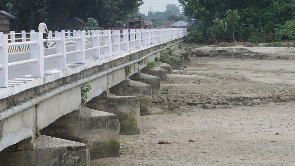
With time, the bridge over the Mahuli River along the East-West Highway has become shorter than the level of the river itself. During the construction of the bridge, the river wasn't this wide.
"In the beginning, the height of the bridge was almost equal to the settlement area," said local Gayadhar Sada, adding, "But now, the level of the river, the height of bridge and the settlement is almost equal."Locals blame the rampant excavation in Chure for this. "The increasing excavation in Chure has weakened the base of the river due to which trees, gravel, sand, pebbles and stones among others pile in various rivers of Tarai, increasing the level of the water," said Shiva Lal Yadav Saday who lives near the Mahuli River.
The Chure range occupies 12.78 % of the total land area of Nepal. Unchecked extraction of resources from the Chure range has directly affected the quality of rivers flowing through it. Former member of PCTMP, Dr Yadav stressed the need for controlling the exploitation in Chure to prevent the risks of floods and landslides.
You May Like This

60 Chure households facing drinking water crisis
DADELDHURA, July 9: The drying up of water sources in the Chure area due to haphazard excavation has compelled the locals... Read More...
Oli says he's true friend of Madhes
KATHMANDU, Mar 10: Prime Minister KP Sharma Oli on Saturday tried to project himself as "a friend of Madhes", capitalizing... Read More...
Ban on Chure excavation being largely violated
JHAPA, Sept 1: Just three weeks ago, massive floods wreaked havoc in Madhes. Landslides in the hilly districts displaced hundreds of... Read More...




Just In
- Challenges Confronting the New Coalition
- NRB introduces cautiously flexible measures to address ongoing slowdown in various economic sectors
- Forced Covid-19 cremations: is it too late for redemption?
- NRB to provide collateral-free loans to foreign employment seekers
- NEB to publish Grade 12 results next week
- Body handover begins; Relatives remain dissatisfied with insurance, compensation amount
- NC defers its plan to join Koshi govt
- NRB to review microfinance loan interest rate





Leave A Comment