Sunday, 28 April 2024 10:10 PM
OR
Login using
Nepal-India agree on reducing height of Saptakoshi Dam by around 31 meters
Published On: October 17, 2023 01:30 PM NPT By: Republica | @RepublicaNepal
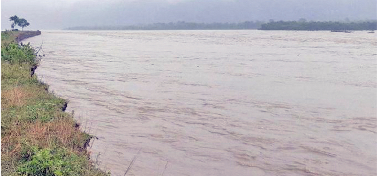
KATHMANDU, Oct 17: It has been agreed to reduce the height of Saptakoshi High Dam Multipurpose Project and Sunkosi Storage Low Diversion Project. The 17th meeting of the Nepal-India joint expert team formed in connection with the study of the Saptakoshi High Dam Multi-Purpose Project and the Sunkoshi Storage and Diversion Project, held from October 9 to 11, agreed to reduce the height of the dam of the project by about 31 meters.
Director general of the Department of Electricity Development, Chiranjeevi Chataut said that it was agreed to reduce the height of the dam from 335.25 meters to 304.8 meters. "We discussed reducing the height of the dam by about 31 meters from sea level," he said, "The details will be finalized only after the detailed project report (DPR) of the project is prepared."
Director General Chataut said that the dam height is going to be reduced due to water consumption and environmental protection. “This project has not yet been studied in detail,” he said, “In the next 30 months, a detailed study of the project is going to be conducted.”
According to the Ministry of Energy, the reduction in the height of the dam will reduce the amount of energy to be produced to about 3000 MW against the earlier projection of 3,489MW.
Nabin Raj Singh, joint secretary and spokesperson for the Ministry of Energy, Water Resources and Irrigation, said that there was an agreement to reduce the height of the dam by taking into consideration the area to be submerged because of the Saptakoshi project, the projects proposed in the upper coastal area and the social, environmental and technical aspects.
"According to the directives of the ninth meeting of the Joint Committee on Water Resources, a study report on the revised size and type prepared by the project was presented," he said, "After a detailed discussion on the same subject, it was agreed to reduce the height of the dam."
According to the press release issued by the Ministry of Energy, it was agreed to carry forward the re-regulating of the barrage at a suitable new location as an alternative to the proposed re-regulating barrage in Sisauli, as well as the study work related to irrigation in Nepali territory in collaboration with the Department of Water Resources and Irrigation (DWRI) Nepal.
It has been agreed to prioritize and prepare a detailed project report in 30 months as important study works such as geological study, environmental impact assessment and rehabilitation and re-establishment studies are yet to be conducted. According to the feasibility study report prepared by the Government of India in 1981 for this project, there will be a 269 meter high concrete dam on the rock surface below the water level in the Saptakoshi River, 1.6 km north of Baraha Kshetra.
Saptakoshi is a major river of Nepal formed by seven large tributaries. Among these tributaries, Sunkoshi, Arun and Tamakoshi rivers originate in Tibet, the neighboring country of China, while Indravati, Likhu, Dudhkoshi and Tamor originate in Nepal. The Saptakoshi River joins the Ganga River at a place called Kursela in India. In 1946, an on-site survey was conducted by the Government of India for the study of the Saptakoshi High Dam Project.
Based on the survey, a feasibility study report of the project was prepared by the Government of India in 1981. The report mentions that both Nepal and India can benefit from irrigation, electricity and flood control from the Saptakoshi High Dam.
In 1985, with the help of JICA, when Nepal prepared the master plan for the development of water resources of the Koshi River basin, it was recommended to give priority to the development of the Sunkoshi Storage and Diversion Project as well as this plan. According to the report of the master plan, it has been mentioned that in addition to generating electricity from the diversion project, irrigation facilities will also be provided to the land on both banks of the Kamala River and flood control will be done on the lower banks of the Kamala River.
You May Like This
Nepal playing against India in SAFF Championship 2021 final today
KATHMANDU, OCT 16: Nepal is taking on India in the final game of the 13th edition of the South Asian Football... Read More...
Assessing military diplomacy
Naravane’s visit has been seen as a significant event as it comes at a time when relations between India and... Read More...

Further deepening Nepal-India ties emphasized
KATHMANDU, Jan 25: The age-old Nepal-India relations should be further deepened and strengthened as per the need of the new... Read More...

Vote counting update: NC takes lead in Ilam-2
6 hours ago
Vote count update: NC maintains lead in Ilam-2
3 hours ago

Nepal Investment Summit-2024 kicks off today
13 hours ago


Vote count update: NC maintains lead in Ilam-2
3 hours ago
Just In
- NEA Provincial Office initiates contract termination process with six companies
- Nepal's ready-made garment exports soar to over 9 billion rupees
- Vote count update: UML candidate continues to maintain lead in Bajhang
- Govt to provide up to Rs 500,000 for building houses affected by natural calamities
- China announces implementation of free visa for Nepali citizens
- NEPSE gains 14.33 points, while daily turnover inclines to Rs 2.68 billion
- Tourists suffer after flight disruption due to adverse weather in Solukhumbu district
- Vote count update: NC maintains lead in Ilam-2
Leave A Comment