Saturday, 27 July 2024 09:48 AM
OR
Login using
Residents of Nabhi, Gunji and Kuti used to pay land revenue to Nepal until 2035 BS
Published On: May 30, 2020 02:13 PM NPT By: Bhuwan Sharma
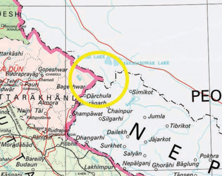
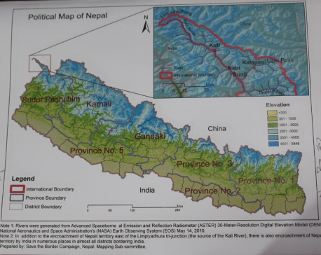
KATHMANDU, May 30: Nepal has recently unveiled its updated map incorporating its territories of Kalapani, Limpiyadhura and Lipulekh, currently encroached upon by India. Gunji, Nabhi and Kuti villages of the region have been included in the newly released map of Nepal.
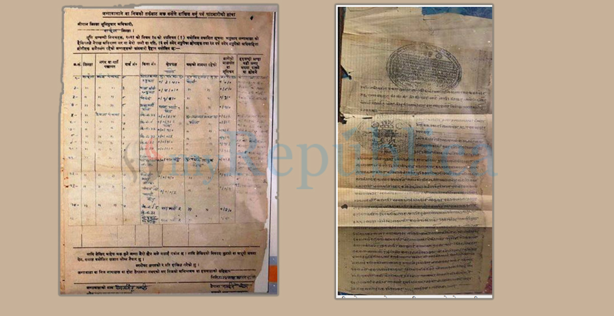
Amid claims from both Nepali and Indian sides on the disputed regions, evidence has been found that the locals of Gunji, Nabhi and Kuti used to pay Bali (land revenue) to the Nepal government until 2035 BS. The government has safely kept the receipts of land taxes paid by Ratan Budha (Tinkar), Panchhyaura Budha (Budi), Mohan Singh Budha (Gabryang), Hari Singh Budha (Gunji) and Hari Krishna Budha (Nabhi).
The government has also the archive of details of land owned by Gunji, Nabhi and Kuti people. Dwarikanath Dhungel, the then Chief District Officer (CDO) of Darchula, had reached Gunji in 2038 BS while returning to Darchula from Kalapani. When he had a talk with locals, they had told him that they had also obtained Nepali citizenship certificates. “I have also learnt that documents related to the land ownership of Gunji, Nabhi and Kuti people were kept at the Land Reforms Office’s Seven Number Form,” Dhungel said. Those details have now been kept at the Department of Survey.
According to a source at the Ministry of Land Management, Minister Padma Aryal gathered more than a dozen pieces of evidence before replacing the existing map with the new one. As many as 132 maps were collected according to the source at ministry. Even in the maps prepared by India, Kalapani, LipuLekh and Limpiyadhura regions have been placed on the Nepali side. More than a dozen such types of maps have been found according to the ministry source.
The government also has an archive of the directive issued by the then prime minister Chandra Shumsher. According to that directive, the disputed regions of Lipulekh, Kalapani and Limpiyadhura belong to Nepal. It was issued when a dispute erupted between two villages of that region. “Use the land on common understanding and pay taxes on a regular basis.You are my people,” it reads.
The most important and the strongest evidence to claim those regions is the Sugauli Treaty inked between Nepal and erstwhile East India Company on March 4, 1816. The then royal priests Gajraj Mishra and Chandra Sekhar Upadhyay were signatories from the Nepali side while Colonel Parish Brad Shaw was the British representative.The treaty states that the land lying to the east of the Kali (Mahakali) River belongs to Nepal. Another complementary treaty was signed after nine months, which the government has considered as the second important proof to claim that territory.
The 1816 Treaty had not included the plain land lying between Koshi River in the east and Rapti in the west. The complementary Treaty on December 8, 1816 states that land within Koshi and Rapti have been given back to Nepal. The British government had sent a letter to Nepal on December 8, 1816 regarding the return. Nepal had prepared its map based on those two treaties including Limpiyadhura areas in the western frontier. It is another strong evidence, according to the government.
Nepal had signed yet another treaty with the British government, which had been ruling the south Asian countries including India. The treaty was signed by Nepal’s Prime Minister Jung Bahadur Rana and British Lieutenant General George Ramsay returning Banke, Bardiya, Kailali and Kanchanpur to Nepal. The map was updated during that time which also states that Nepal’s western border extends upto Limpiyadhura.
The British government, later on January 7, 1975, prepared another map of Nepal after demarcating the boundary of Dang. This map also shows Limpiyadhura as the western border.
Similarly, Nepal has also kept the electoral roll of the 1959 general election and census conducted in 2018 BS as other pieces of evidence to justify that the disputed regions of Kalapani, Lipulekh and Limpiyadhura lie within the Nepali border.
According to the Survey Department, Nepal has also archived the map brought from the United Kingdom. Sources said that other stronger pieces of evidence have also been found. Study is underway on those proofs.
You May Like This
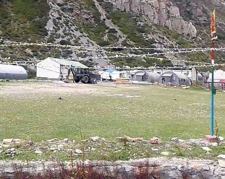
India unilaterally constructs link road to Tibet through Nepali territory of Lipulekh
KATHMANDU, May 9: India on Friday inaugurated a strategic link road connecting Dharchula of the Indian State of Uttarakhand and... Read More...
Issue new map comprising Indian-encroached areas: House panel
KATHMANDU, Dec 14: The International Relations Committee of the parliament has directed the government to issue a new political map... Read More...
NC lawmaker criticizes govt for failing to retrieve Nepali territory Kalapani occupied by India
KATHMANDU, Dec 23: The main opposition Nepali Congress has criticized the government for failing to take concrete measures to bring... Read More...
NRB unveils monetary policy
20 hours ago


NRB set to issue monetary policy today
22 hours ago


Girl found unconscious at Gwarko guest house dies
23 hours ago

Heavy rainfall likely in Bagmati and Sudurpaschim provinces
16 minutes ago
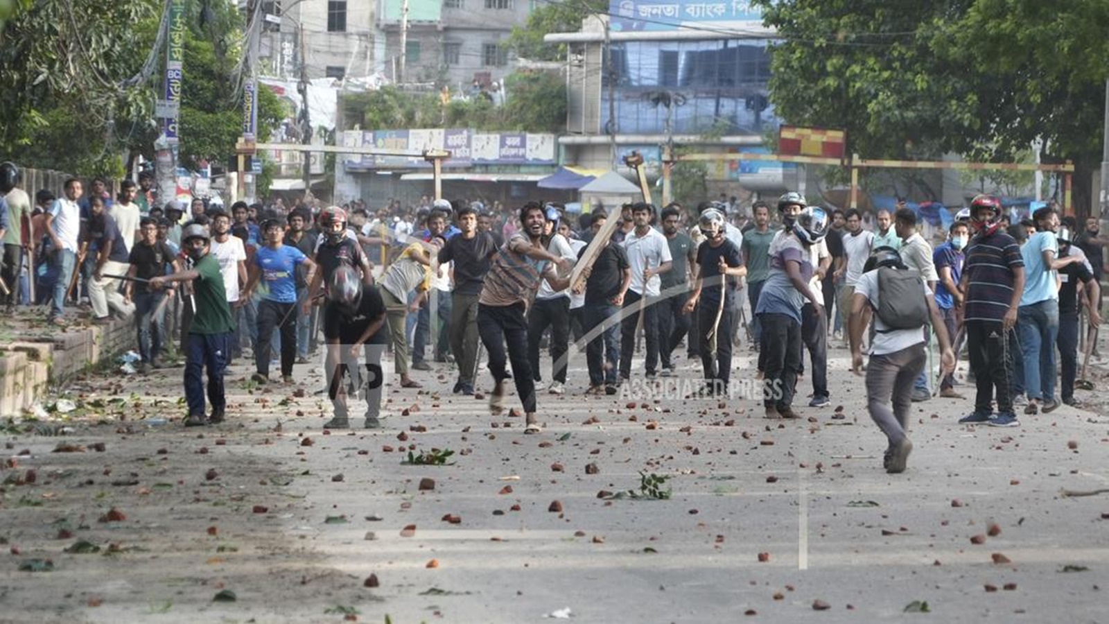
Bangladesh protest leaders taken from hospital by police
18 minutes ago
Challenges Confronting the New Coalition
53 minutes ago

NEB to publish Grade 12 results next week
12 hours ago
Just In
- Heavy rainfall likely in Bagmati and Sudurpaschim provinces
- Bangladesh protest leaders taken from hospital by police
- Challenges Confronting the New Coalition
- NRB introduces cautiously flexible measures to address ongoing slowdown in various economic sectors
- Forced Covid-19 cremations: is it too late for redemption?
- NRB to provide collateral-free loans to foreign employment seekers
- NEB to publish Grade 12 results next week
- Body handover begins; Relatives remain dissatisfied with insurance, compensation amount
Leave A Comment