Saturday, 27 July 2024 09:25 AM
OR
Login using
Nepal strongly objects to India's new political map that has placed Kalapani inside Indian borders: MoFA
Published On: November 6, 2019 06:01 PM NPT By: Republica | @RepublicaNepal
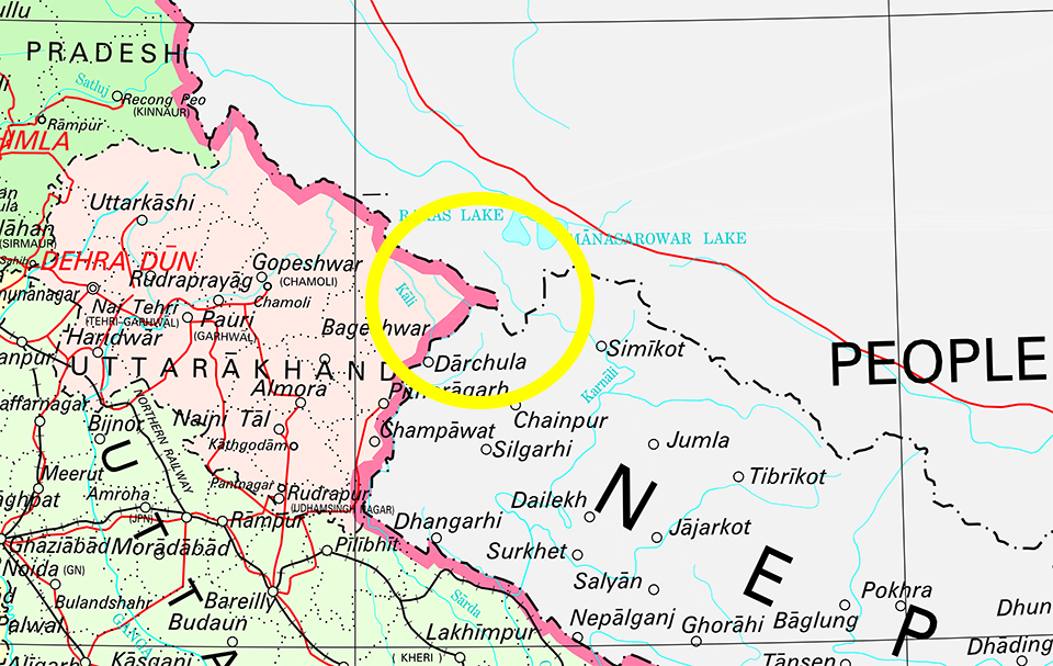
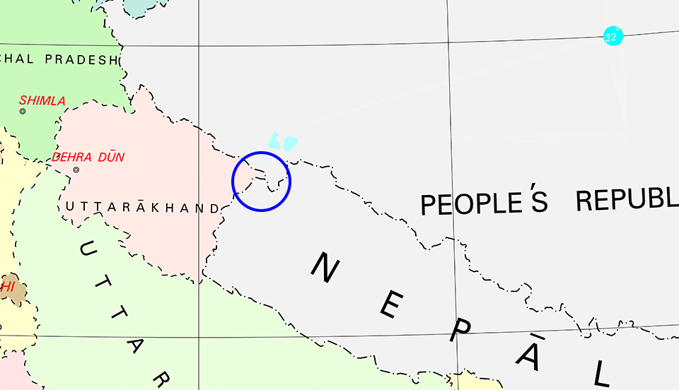
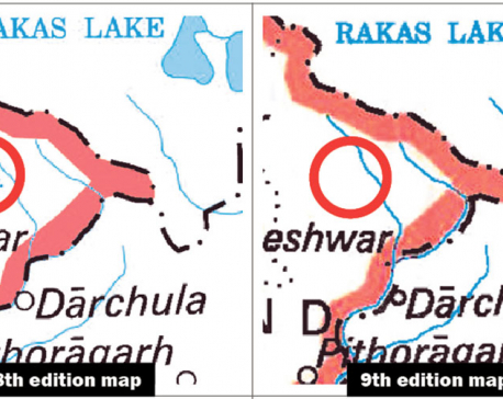
KATHMANDU, Nov 6: Nepal has strongly objected to a recently-unveiled political map by the Indian government that has placed Nepali territory Kalapani inside Indian borders.
Four days after the Indian Home Ministry released the political map placing Nepali territory Kalapani inside Indian borders after creating Jammu and Kashmir and Ladakh as its union territories, the Ministry of Foreign Affairs asserted on Wednesday that Kalapani is an integral part of Nepal.
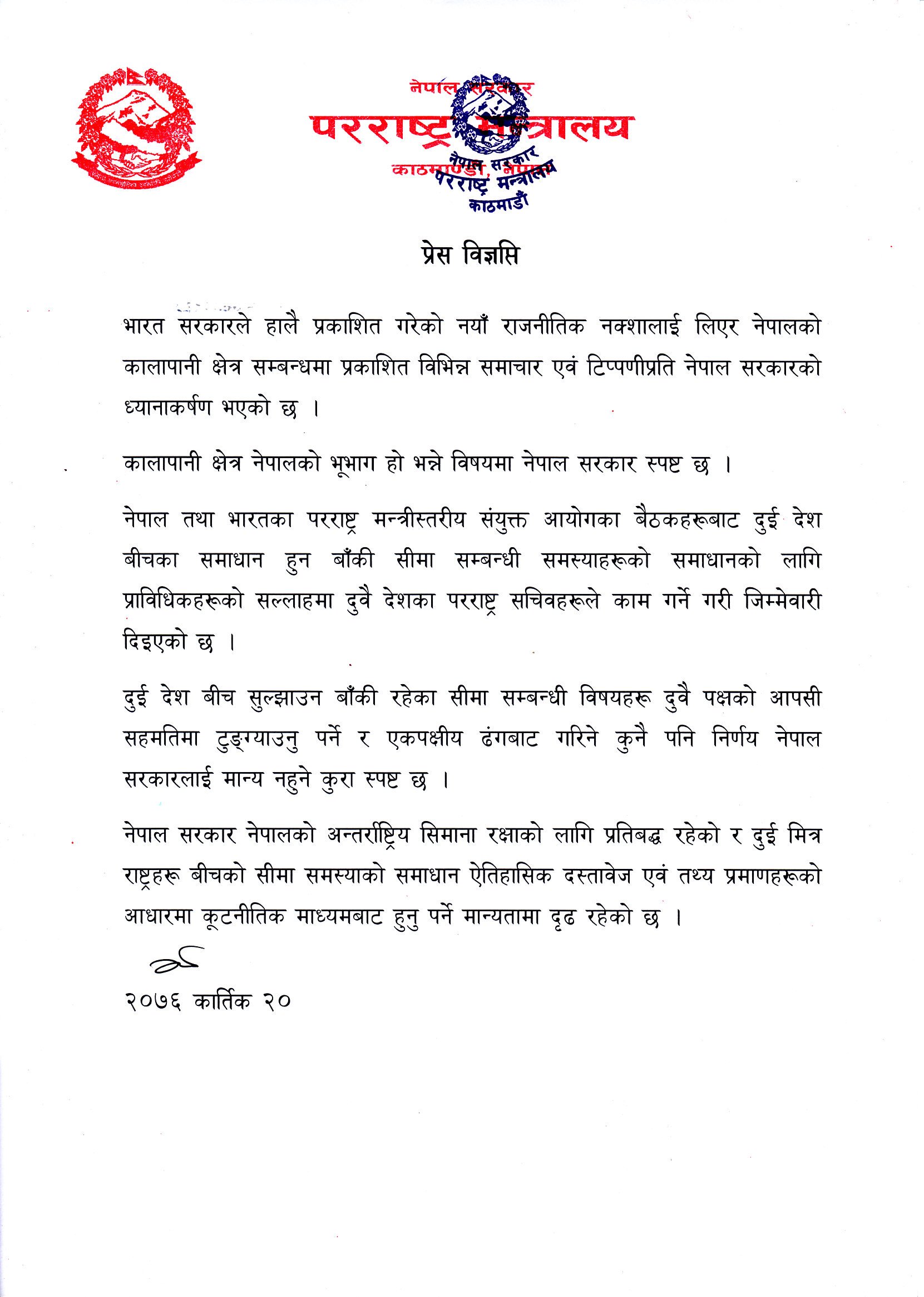
"The Nepal government firmly believes that the Kalapani is a part of Nepal," read a press statement issued by the ministry.
The ministry said that any unilateral actions along the Nepal-India border will be unacceptable to the Nepal government since the foreign secretaries of the two countries have already been assigned by the Nepal-India Joint Commission to find a solution on the unresolved border disputes in consultation with the border experts.
"The remaining issues related to the border should be resolved in bilateral consensus and any unilateral actions will be unacceptable to the Nepal government," the press statement said.
It said that the government's attention has been drawn towards the media reports and comments over Nepali territory Kalapani while relating it with the new Indian political map.
"The Nepal government is committed to protecting the country's external borders and it is determined on its principled position that such border disputes with the neighboring countries should be resolved through diplomatic channels after assessing the historical documents, facts, and evidence," the ministry added.
You May Like This
Issue new map comprising Indian-encroached areas: House panel
KATHMANDU, Dec 14: The International Relations Committee of the parliament has directed the government to issue a new political map... Read More...
Govt forms committee for border inspection
KATHMANDU, Nov 22: The government has formed a committee to inspect Nepal’s borders with India and China, following the controversy... Read More...
India has encroached upon two percent Nepali territory, says government spokesperson
KATHMANDU, Nov 7: The government will hold talks with the southern neighbor India to resolve existing border disputes through diplomatic... Read More...
NRB unveils monetary policy
19 hours ago


NRB set to issue monetary policy today
21 hours ago

Girl found unconscious at Gwarko guest house dies
22 hours ago
Challenges Confronting the New Coalition
30 minutes ago
NEB to publish Grade 12 results next week
12 hours ago
NC defers its plan to join Koshi govt
13 hours ago

NRB to review microfinance loan interest rate
13 hours ago
Just In
- Challenges Confronting the New Coalition
- NRB introduces cautiously flexible measures to address ongoing slowdown in various economic sectors
- Forced Covid-19 cremations: is it too late for redemption?
- NRB to provide collateral-free loans to foreign employment seekers
- NEB to publish Grade 12 results next week
- Body handover begins; Relatives remain dissatisfied with insurance, compensation amount
- NC defers its plan to join Koshi govt
- NRB to review microfinance loan interest rate
Leave A Comment