Sunday, 28 April 2024 11:54 PM
OR
Login using
Nepal has 28 percent arable land and 42 percent forest cover
Published On: February 16, 2024 06:40 PM NPT By: Bhuwan Sharma
_20240214184451.jpg)
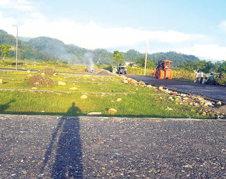
KATHMANDU, Feb 16: The Department of Survey (DoS) has revealed land use data prepared from 2066 BS to 2075 BS. The data shows that the total arable land across the country is 41,275.54 square kilometers which constitutes 27.89 percent of the total land. Similarly, the data shows that the forest area in the country is 61,739.98 square kilometers or 41.71 percent of the total land.
After integrating the data from across the country, the technicians at the DoS have divided the land into 11 clusters. The Land Use Act, 2076 and Land Use Regulations, 2078, have classified the land into 11 types.
According to the technical staff of the DoS, the classification is based on the total land measured across the country as explained in the Act. According to the classification, the land with mining and mineral areas is very limited, comprising only 25.85 square kilometers which is 0.02 percent. Similarly, the land occupied by the industrial sector is also very less.
It is found that such land is 94.98 square kilometers. When measured as a percentage, it becomes 0.06. According to the data, the area occupied by the cultural and archaeological area is 14.33 square kilometers consisting only 0.01percent. According to the technical staff of the DoS, such land is the least seen among the classified land.
Similarly, the land use for commercial purposes is 79.43 square kilometers across the country. When measured as a percentage, it comes to 0.05 percent.
Similarly, the land use for public use is 11,466.75 square kilometers across the country. Putting it in percentage, it becomes 7.71. The land classified for residential purposes is 1,980.11 square kilometers or 1.34 percent of the total land across the country.
Similarly, the total land occupied by rivers and ponds is 4,937.32 square kilometers or 3.34 percent. According to the DoS, the conservation area of the country is 4,568.71 square kilometers or 3.009 percent.
Apart from these clusters, the land in other clusters is 21,884.59 square kilometers across the country, which is 14.79 per cent.
The DoS has classified the land across the country into 11 clusters based on satellite images. The description has been prepared based on the current land use. A senior technical officer of the DoS stated that this classification of land use is not accurate all the time. There seems to be some fluctuations in data. “Agricultural, forest, residential land use sometimes fluctuates on its use,” he said.
Employees of the DoS have already handed over the land use data prepared by the DoS to all 753 local governments.
Initially, this project was under the then Ministry of Land Reform and Management, the National Land Use Project, established in 2057 BS with the aim of classifying the land across the country on the basis of use. But it was not implemented at first. However, it commenced in 2066 BS. In the year 2074 BS, the project was dissolved and its responsibilities were transferred to the DoS where the technical staff continued the work.
You May Like This
Plotting of Valley-based residential land with area less than 4 aana 1 daam prohibited
KATHMANDU, June 7: The government has barred the plotting of residential land in the Kathmandu Valley if the area of such... Read More...

Vote counting update: NC takes lead in Ilam-2
8 hours ago

Vote count update: NC maintains lead in Ilam-2
5 hours ago

Nepal Investment Summit-2024 kicks off today
15 hours ago


Vote count update: NC maintains lead in Ilam-2
5 hours ago
Just In
- NEA Provincial Office initiates contract termination process with six companies
- Nepal's ready-made garment exports soar to over 9 billion rupees
- Vote count update: UML candidate continues to maintain lead in Bajhang
- Govt to provide up to Rs 500,000 for building houses affected by natural calamities
- China announces implementation of free visa for Nepali citizens
- NEPSE gains 14.33 points, while daily turnover inclines to Rs 2.68 billion
- Tourists suffer after flight disruption due to adverse weather in Solukhumbu district
- Vote count update: NC maintains lead in Ilam-2
Leave A Comment