Saturday, 20 April 2024 07:43 AM
OR
Login using

Jugmani Chaudhary: A land rights activist making strides in Western Nepal
March 8, 2024 15:20 pm
Jugmani Chaudary searches for the records of registration of land. She is fully involved in the authentication of land distributed by the rural municipality. Equipped with her measuring tape, she visits the Office of Land Measurement, enters data into the computer system, and ensures the dissemination of information regarding land ownership and statistics of landless residents on the National Land Commission's website. Her expertise extends to analyzing satellite images of land, making her an invaluable asset in the field.
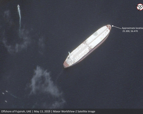
Satellite images show oil tankers allegedly sabotaged
May 14, 2019 11:00 am
DUBAI, May 14: New satellite photos obtained by The Associated Press show the oil tankers that Gulf officials alleged were the targets of “sabotage” off the coast of the United Arab Emirates.
Trending


Just In
- Fixing a win by outlawing dissent damages democracy
- MoHP cautions docs working in govt hospitals not to work in private ones
- Over 400,000 tourists visited Mustang by road last year
- 19 hydropower projects to be showcased at investment summit
- Global oil and gold prices surge as Israel retaliates against Iran
- Sajha Yatayat cancels CEO appointment process for lack of candidates
- Govt padlocks Nepal Scouts’ property illegally occupied by NC lawmaker Deepak Khadka
- FWEAN meets with President Paudel to solicit support for women entrepreneurship